
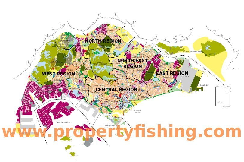
Singapore’s latest Master Plan 2014 has been gazetted on 6 六月 2014.
The Master Plan 2014 is the statutory land use plan that guides the physical development of Singapore for the medium term (~5 years).
As part of the Master Plan, 都 75 heritage buildings proposed for conservation under the Draft Master Plan 2013 were also gazetted today:
- Leong San See Temple, 371 Race Course Road
- Ban Siew San Temple, 2 Telok Blangah Drive
- Koon Seng Ting Temple, 4 Telok Blangah Drive
- Tang Gah Beo, 6 Bukit Purmei
- Kiew Lee Tong Temple, 5 Jalan Tambur
- Sian Keng Tong, 216 樟宜路
- Former Chee Kong Tong (Thekchen Choling) Entrance Gate, 2 Beatty Lane
- Sri Veeramakaliamman Temple, 141 實龍崗路
- Sri Manmatha Karuneshvarar Temple, 226 Kallang Road
- Sri Vadapathira Kaliamman Temple, 555 實龍崗路
- Sri Krishnan Temple, 152 Waterloo Street
- Angullia Mosque Gatehouse, 265 實龍崗路
- Malabar Mosque, 471 Victoria Street
- Wak Tanjong Mosque, 25 Paya Lebar Road
- Former St Matthew’s Church & 幼稚園, 184 Neil Road
- Former Institute of Health (Bestway House), 226 Outram Road
- Alexandra Hospital, 378 Alexandra Road
- 394 Alexandra Road
- Queenstown Public Library, 53 玛格丽特驅動器
- Former Commonwealth Avenue Wet Market, 38 Commonwealth Avenue
- Former Field Assistant’s House (Institute Of Policy Studies) & The Garage at Singapore Botanic Gardens
- 142 Moulmein Road (Department Of Clinical Epidemiology – 谭托克森醫院), 144 Moulmein Road (Tuberculosis Control Unit)
- 5 blocks of Singapore Improvement Trust flats at Kampong Silat (18, 19, 22, 23 & 24 Silat Avenue)
- Robertson Quay Warehouses (17, 19 & 21 Jiak Kim Street; 19 & 20 Merbau Road; 41 & 42 罗伯逊碼頭, 63 Caseen Street and 72-13 Mohamed Sultan Road)
- Former Royal Air Force Seletar (張 179 & 450; 1, 2 & 226 Park Lane; 1 自 3 & 5 Hamilton Place; 3, 5A 個, 7, 9 自 13, 15 Hyde Park Gate; 1 自 16 The Oval)
源: Urban Redevelopment Authority
Other areas gazetted for development include:
果園
As Singapore’s premier shopping belt, Orchard Road is a vibrant and exciting street lined with shopping malls, hotels, and food and beverage offerings. The grand tropical boulevard running through the district has long been a people magnet, always bustling with vibrant street life.
Orchard Road is predominantly a retail belt and is mainly zoned Commercial to support a mix of shops, offices and hotels. There are also several sites zoned for Hotel use to enhance the
attractiveness of Orchard Road as one of Singapore’s key tourist destinations.
This is supplemented by a number of Residential and mixed Commercial & Residential sites that inject a live-in population to the area to ensure round-the-clock vibrancy.
A generous tree-lined pedestrian mall runs through the district, connecting major developments, public open spaces and MRT stations.
URA would like to make Orchard a walkable and pedestrian-friendly district with an attractive and vibrant streetscape by ensuring seamless, all-weather connectivity and accessibility between developments and the MRT stations, and by encouraging innovative design, varied building forms, public spaces and various active uses along the Orchard Road pedestrian mall.
Nearby developments:
城市度假村
古德伍德公寓
個巴尔莫勒尔
Bras Basah/Bugis
The Bras Basah/Bugis district is strategically located close to the premier Orchard Road shopping belt and the Civic District.
Envisioned to be a lively, 藝術, learning and heritage enclave, Bras Basah/Bugis is home to many of Singapore’s arts and cultural facilities, including the Singapore Art Museum, Waterloo Street Arts Belt, LaSalle College of the Arts, Nanyang Academy of Fine Arts and School of the Arts (索塔).
Bras Basah/Bugis has an eclectic mix of uses and building types. These include shophouses, standalone religious buildings, schools, as well as medium to large-scale commercial buildings, and public housing.
市中心核心
The Downtown Core Planning Area covers the Central Business District (Cbd), 市政廳, 武吉士, and Marina Centre zones. It comprises a critical mass of prime office space, supported by complementary uses, such as hotel, 零售, and residential uses.
The Downtown Core is a vibrant commercial district with round-the-clock activities.
Nearby developments:
SBFC Centre
斯波蒂斯伍德住宅
城市大門
新加坡河
The Singapore River Planning Area stretches 3km long and covers Boat Quay, 克拉碼頭, and Robertson Quay subzones. It has a good variety of commercial uses, supported by complementary uses such as hotel and residential uses.
Singapore River is today a vibrant waterfront destination that offers various lifestyle options and quality waterfront city living. The Singapore River Planning Area is envisioned to be an exciting activity corridor that capitalises on the river frontage and reflects its unique historic character.
A tree-lined pedestrian promenade and bridges have been implemented along both banks of the river, connecting the three quays and enhancing the pedestrian friendliness along the river corridor.
Nearby developments:
碼頭公寓
Nathan Suites
蒙大拿州